"Turn Any Property Into a Smarter Hunting Plan"
-HuntMap AI delivers AI-assisted hunting strategy reports with high-probability stand locations, movement corridors, and wind-optimized setups — delivered in 48–72 hours.
🗺️ New Lease or New Property?
Get a complete stand placement strategy built from terrain and wind trends.🎯 Already Have Stands & Cameras?
Upload your current setup and let AI optimize locations and movement strategy.
↓ How it works ↓
Step 1: Upload Your Land
Take a screenshot from Google Maps, OnX, or an aerial topo view of your property. (Draw your Boundary)
Step 2: Mark Your Setup (Optional)
Use Apple Markup or our Google My Maps template (optional) to add stands, food plots, trail cams, and deer movement for deeper analysis — or simply upload your basic property map.
Step 3. Get Your Custom Plan
We’ll combine your map with terrain & wind data, then send you a complete stand strategy — showing exactly where to hunt, and why.
What you'll get
High-probability stand location recommendations
Wind-optimized hunting setups
Strategic insights tailored to your property
A clear, easy-to-follow hunting strategy report
Clear explanation of why it works
Delivered in 48–72 hours
HuntMap AI provides AI-assisted strategic hunting insights. Results are not guaranteed. Hunters are responsible for verifying legality, access, and safety.
Choose your HuntMap AI Plan
| Feature | (Starter) Up to 100 acres | (Standard) 101–300 acres | (Premium) 301+ acres |
|---|---|---|---|
| Marked Topo + Satellite Maps | Yes | Yes | Yes |
| Stand Locations & Wind Strategy | Yes | Yes | Yes |
| Entry / Exit Routes | Basic | Detailed | Detailed |
| Food Plots + Trail Cam Tips | — | Yes | Yes |
| In-Depth Written Strategy | Basic | Full | Full |
| One Revision Round | — | — | Yes |
| Rut Adjustments + Extra Guide | — | — | Yes |
| Priority Delivery | — | — | Yes |
| Price | 79.99$ | 129.99$ | 199.99$ |
After purchase is confirmed there will be a link to our Google Property Intake Form to upload your maps:I’ll deliver your custom HuntMap AI blueprint in 48–72 hours.
Already Have a Setup? Show Us Your Hunt Map
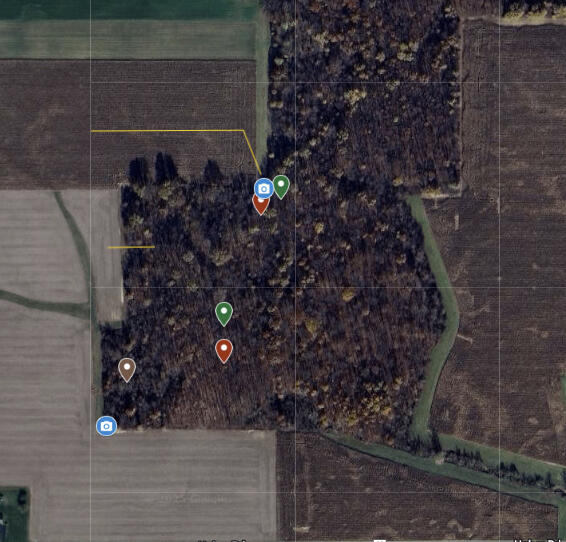
Use our Google My Maps template to mark your hunting areas with designated points of access, possible stand locations , and other landmarks.
Contact us
Any Questions?
Questions? I’ve Got You.
Whether it’s uploading your land, marking your stands, or figuring out where to start — I’ll guide you through it.
[email protected]
About Me
I built HuntMap AI for hunters who don’t have weeks to scout. I combine years of deer hunting experience with AI-powered tools to give you the best chance at success.